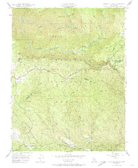
1947 Map of Jawbone Ridge
USGS Topo · Published 1974About this map
Stanislaus National Forest land dominates this 1940s landscape, revealing a complex network of resource management and early Sierra tourism. The infrastructure of the Hetch Hetchy Aqueduct (South Channel) and the Hetch Hetchy Trail cut across the central terrain, marking the vital water-conveyance systems serving distant urban centers. Small outposts and service points like Smith Station and the Groveland Ranger Sta indicate the administrative and travel-related hubs of the era, while the Gold Queen Mine (Abandoned) and Argo Mine point to an earlier era of mineral extraction that shaped the local geography.
Find a feature on this map
56 named features on this map. Tap any name to fly to it.
Don’t see what you’re looking for? This feature index may not catch every label — zoom into the map to look around manually.
Map Details
Editions of this 1947 Jawbone Ridge Map
3 editions found
Other maps of this area

1893 · Sonora
USGS Topo · 1:125,000

1896 · Sonora
USGS Topo · 1:125,000

1897 · Sonora
USGS Topo · 1:125,000

1897 · Yosemite
USGS Topo · 1:125,000

1898 · Sonora
USGS Topo · 1:125,000

1900 · Yosemite
USGS Topo · 1:125,000

1903 · Yosemite
USGS Topo · 1:125,000

1909 · Yosemite
USGS Topo · 1:125,000

1947 · San Jose
USGS Topo · 1:250,000

1947 · Mariposa
USGS Topo · 1:250,000