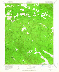
1947 Map of Groveland
USGS Topo · Published 1964About this map
Groveland and the surrounding Gold Country terrain are captured here just after the post-war era, showing a landscape defined by 19th-century mining legacy and critical mid-century water infrastructure. The map highlights the legendary Bret Harte Cabin and the nearby settlement of Second Garrotte, remnants of the region's feverish prospecting years. The Hetch Hetchy Aqueduct cuts a prominent line across the high ground, illustrating the massive engineering efforts required to move water from the Sierra Nevada to the coast. Cultural sites such as Elmore Temporary Sch and the Servaes Temporary Sch appear alongside established mining features like the Kanske Mine and Red Jacket Mine. The terrain is steeply textured by a series of parallel heights including Jackass Ridge and Wagner Ridge, dropping toward the Tuolumne River in the northeast and Shanahan Flat in the southeast.
Find a feature on this map
35 named features on this map. Tap any name to fly to it.
Don’t see what you’re looking for? This feature index may not catch every label — zoom into the map to look around manually.
Map Details
Editions of this 1947 Groveland Map
4 editions found

Other maps of this area

1893 · Sonora
USGS Topo · 1:125,000

1896 · Sonora
USGS Topo · 1:125,000

1897 · Sonora
USGS Topo · 1:125,000

1898 · Sonora
USGS Topo · 1:125,000

1944 · Merced Falls
USGS Topo · 1:62,500

1947 · San Jose
USGS Topo · 1:250,000

1947 · Coulterville
USGS Topo · 1:62,500
1947 · Jawbone Ridge
USGS Topo · 1:24,000
1947 · Buckhorn Peak
USGS Topo · 1:24,000
1947 · Coulterville
USGS Topo · 1:24,000