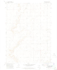
1972 Map of Grover NE
USGS Topo · Published 1975About this map
High plains terrain and agricultural infrastructure characterize this 1972 survey of northeast Weld County. The landscape is defined by the ephemeral drainage of Sidney Draw and a dispersed network of rural landmarks that reveal the spiritual and industrial life of the community. Local history centers on the Zion Ch and an adjacent Cem, which serve as a focal point for the surrounding homesteads. Evidence of the region's modernization is visible in the prominent Pipeline crossing the northern section, a Substa, and various communication structures including a Radio Tower and Tower. The presence of a Drill Hole and the Rapid radio marker suggests the area's role in supporting regional energy and aviation networks during the early 1970s.
Find a feature on this map
9 named features on this map. Tap any name to fly to it.
Don’t see what you’re looking for? This feature index may not catch every label — zoom into the map to look around manually.
Map Details
Editions of this 1972 Grover NE Map
3 editions found
Other maps of this area

1954 · Sterling
USGS Topo · 1:250,000

1954 · Scottsbluff
USGS Topo · 1:250,000

1954 · Cheyenne
USGS Topo · 1:250,000

1954 · Greeley
USGS Topo · 1:250,000

1957 · Greeley
USGS Topo · 1:250,000

1958 · Cheyenne
USGS Topo · 1:250,000

1958 · Greeley
USGS Topo · 1:250,000

1958 · Scottsbluff
USGS Topo · 1:250,000

1958 · Sterling
USGS Topo · 1:250,000

1961 · Greeley
USGS Topo · 1:250,000