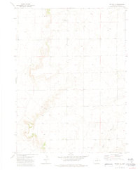
1972 Map of Grover NE
USGS Topo · Published 1975About this map
Sidney Draw winds through this section of Weld County, defining a landscape marked by scattered industrial and community infrastructure in the early 1970s. The map captures the quiet intersection of rural life and modern utility, featuring the Zion Ch and an adjacent Cem located near the southern boundary. These local landmarks provide specific points of interest for genealogists and local historians tracking the development of small communities in this region. The terrain is further characterized by technical installations, including a Substa and multiple communications sites like the Radio Tower at Rapid and additional Radio Towers to the south. Several labeled Well sites across the grid indicate the ongoing importance of water or mineral resources to the local economy during this era.
Find a feature on this map
9 named features on this map. Tap any name to fly to it.
Don’t see what you’re looking for? This feature index may not catch every label — zoom into the map to look around manually.
Map Details
Editions of this 1972 Grover NE Map
3 editions found
Other maps of this area

1954 · Sterling
USGS Topo · 1:250,000

1954 · Scottsbluff
USGS Topo · 1:250,000

1954 · Cheyenne
USGS Topo · 1:250,000

1954 · Greeley
USGS Topo · 1:250,000

1957 · Greeley
USGS Topo · 1:250,000

1958 · Cheyenne
USGS Topo · 1:250,000

1958 · Greeley
USGS Topo · 1:250,000

1958 · Scottsbluff
USGS Topo · 1:250,000

1958 · Sterling
USGS Topo · 1:250,000

1961 · Greeley
USGS Topo · 1:250,000