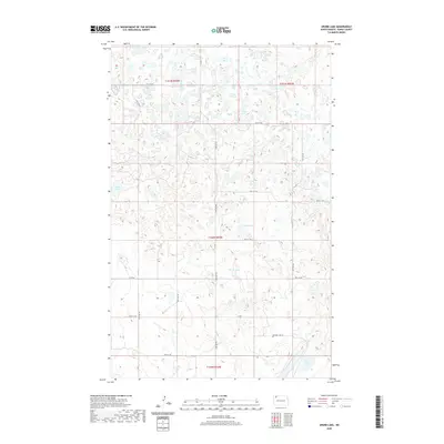
2020 Map of Grubb Lake
USGS Topo · Published 2020About this map
Grubb Lake and the surrounding prairie pothole region of Burke County are defined by a complex network of glacial depressions and wetlands. This modern survey reflects the enduring section-line road system of North Dakota, where routes like 88th St NW and 93rd Ave NW carve a strict grid across the undulating terrain. The landscape is primarily rural and hydrologically rich, featuring named water bodies such as Muskie Lake, Harms Lake, and Fish Lake distributed among dozens of smaller unnamed sloughs and seasonal basins. Notable access points include Smishek Lake Rd in the southern portion of the quadrangle and major local arteries such as Co Rd 16 and Co Rd 7, which facilitate movement through this remote agricultural and sporting landscape.
Find a feature on this map
21 named features on this map. Tap any name to fly to it.
Don’t see what you’re looking for? This feature index may not catch every label — zoom into the map to look around manually.
Map Details
Editions of this 2020 Grubb Lake Map
This is the sole edition of this map. No revisions or reprints were ever made.
Other maps of this area

1948 · Beaver Lake
USGS Topo · 1:24,000

1949 · Rennie Lake
USGS Topo · 1:24,000

1949 · Columbus SE
USGS Topo · 1:24,000

1950 · Columbus
USGS Topo · 1:62,500

1950 · Portal
USGS Topo · 1:62,500

1953 · Williston
USGS Topo · 1:250,000

1957 · Williston
USGS Topo · 1:250,000
1974 · Helde Lake
USGS Topo · 1:24,000

1974 · Grubb Lake
USGS Topo · 1:24,000

1974 · Grand View
USGS Topo · 1:24,000