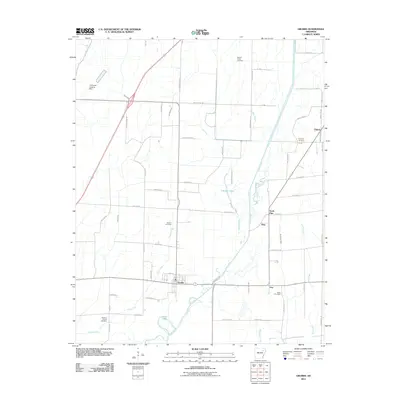
2011 Map of Grubbs
USGS Topo · Published 2011About this map
Grubbs sits at the heart of this delta landscape, where the Cache River and its multiple backwaters dictate the local geography. The map reveals a complex network of drainage ditches and sloughs, such as Tiger Ditch, Skillet Ditch, and Deep Slough, which were essential for managing the fertile but low-lying bottomlands of Jackson County. These hydraulic features, along with Old Channel Cache River, trace the natural and engineered history of the region's agricultural development.
Find a feature on this map
63 named features on this map. Tap any name to fly to it.
Don’t see what you’re looking for? This feature index may not catch every label — zoom into the map to look around manually.
Map Details
Editions of this 2011 Grubbs Map
This is the sole edition of this map. No revisions or reprints were ever made.
Other maps of this area

1935 · Sedgwick
USGS Topo · 1:62,500

1935 · Alicia
USGS Topo · 1:62,500

1935 · Tuckerman
USGS Topo · 1:62,500

1939 · Weiner
USGS Topo · 1:62,500

1953 · Memphis
USGS Topo · 1:250,000

1956 · Memphis
USGS Topo · 1:250,000

1959 · Weiner
USGS Topo · 1:62,500

1959 · Sedgwick
USGS Topo · 1:62,500

1960 · Weiner
USGS Topo · 1:62,500
1960 · Sedgwick
USGS Topo · 1:62,500