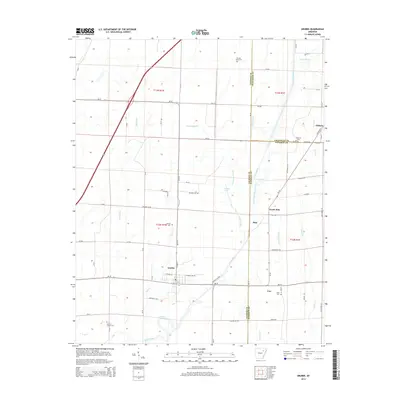
2014 Map of Grubbs
USGS Topo · Published 2014About this map
The Cache River and its intricate drainage network define this Arkansas landscape, where three county lines—Jackson, Craighead, and Poinsett—converge. Small agricultural settlements like Grubbs and Pitts anchor the area, while smaller locales such as Uno, North Pitts, and Chilson dot the intersections of rural roads. The region's hydrography is notably complex, featuring man-made and natural watercourses including Tupelo Slough, Gum Pond Ditch, and Toms Creek. For genealogists, the map preserves the locations of several burial grounds, such as Denton Island Cem, Holloway Cem, and Hankins Sullins Cem, which serve as vital markers of early family settlements. The terrain is characterized by low-lying wetlands and ditches, including Deep Slough and the Old Channel Cache River, illustrating the intensive drainage efforts required to maintain the local farmland between the river forks.
Find a feature on this map
79 named features on this map. Tap any name to fly to it.
Don’t see what you’re looking for? This feature index may not catch every label — zoom into the map to look around manually.
Map Details
Editions of this 2014 Grubbs Map
This is the sole edition of this map. No revisions or reprints were ever made.
Other maps of this area
1935 · Sedgwick
USGS Topo · 1:62,500
1935 · Alicia
USGS Topo · 1:62,500
1935 · Tuckerman
USGS Topo · 1:62,500
1939 · Weiner
USGS Topo · 1:62,500

1953 · Memphis
USGS Topo · 1:250,000
1956 · Memphis
USGS Topo · 1:250,000
1959 · Weiner
USGS Topo · 1:62,500
1959 · Sedgwick
USGS Topo · 1:62,500
1960 · Weiner
USGS Topo · 1:62,500
1960 · Sedgwick
USGS Topo · 1:62,500