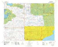
1977 Map of Grygla
USGS Topo · Published 1978About this map
The Red Lake Indian Reservation and the sprawling Beltrami Island State Forest dominate this Northern Minnesota landscape during the late 1970s. This region is defined by an extensive network of drainage infrastructure, such as Judicial Ditch No 11 and various county ditches, which modified the terrain to support the small agricultural communities of Grygla, Gatzke, and Thorhult. The map reveals a land heavily managed for both conservation and timber, featuring the Agassiz National Wildlife Refuge and the Thief Lake State Wildlife Management Area. Local landmarks like the Linder Lookout Tower and Ridge Lookout Tower overlook the wooded tracts, while the Red Lake River flows through the southern reaches. This survey provides a clear view of the rural settlement patterns and the intersection of state, federal, and tribal lands before modern development further altered the wilderness character of the area.
Find a feature on this map
53 named features on this map. Tap any name to fly to it.
Don’t see what you’re looking for? This feature index may not catch every label — zoom into the map to look around manually.
Map Details
Editions of this 1977 Grygla Map
This is the sole edition of this map. No revisions or reprints were ever made.
Other maps of this area

1918 · Winterroad
USGS Topo · 1:62,500

1918 · Rollis
USGS Topo · 1:62,500

1918 · F
USGS Topo · 1:62,500

1918 · Pencer
USGS Topo · 1:62,500

1918 · Terrebonne
USGS Topo · 1:62,500

1918 · Garland
USGS Topo · 1:62,500

1918 · Malcolm
USGS Topo · 1:62,500

1918 · Jelle
USGS Topo · 1:62,500

1918 · Greenbush
USGS Topo · 1:62,500

1918 · Middle River
USGS Topo · 1:62,500