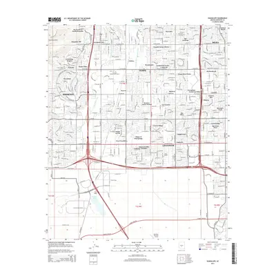
2014 Map of Guadalupe
USGS Topo · Published 2014About this map
Guadalupe sits as a distinct enclave within the rapidly evolving metropolitan landscape of the East Valley. This survey shows the dense residential growth of Phoenix, Tempe, and Chandler as they converge around the northern edges of the Gila River Indian Community. The landscape is defined by its water management systems, including the Western Canal, Kyrene Br Canal, and the N Br Highline Canal, which historically supported the region's agricultural transition. To the southwest, the South Mountains rise sharply from the valley floor, with Javelina Canyon and The Pointe at South Mountain marking the edge of the desert. Aviation and education landmarks are central to this era, from the specialized Stellar Airpark and Gila River Memorial Airport to the Remington College-Tempe Campus. The map provides a detailed view of the modern suburban fabric, tracing developments like The Lakes and the Village of Gila Springs.
Find a feature on this map
78 named features on this map. Tap any name to fly to it.
Don’t see what you’re looking for? This feature index may not catch every label — zoom into the map to look around manually.
Map Details
Editions of this 2014 Guadalupe Map
This is the sole edition of this map. No revisions or reprints were ever made.
Other maps of this area

1912 · Phoenix
USGS Topo · 1:62,500

1913 · Mesa
USGS Topo · 1:62,500

1913 · Maricopa
USGS Topo · 1:62,500

1914 · Gila Butte
USGS Topo · 1:62,500

1914 · Phoenix
USGS Topo · 1:62,500

1915 · Mesa
USGS Topo · 1:62,500

1915 · Maricopa
USGS Topo · 1:62,500

1917 · Gila Butte
USGS Topo · 1:62,500

1952 · Tempe
USGS Topo · 1:24,000

1952 · Chandler
USGS Topo · 1:24,000