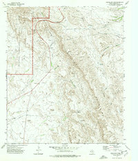
1973 Map of Guadalupe Pass
USGS Topo · Published 1977About this map
Guadalupe Mountains National Park dominates the northwest corner of this West Texas survey, where the high peaks of the range drop sharply toward the Delaware Mountains. The terrain is defined by a series of deep drainages and ridges, including Glover Canyon and the winding Brushy Canyon. Human presence in this arid landscape is concentrated along the transit corridor of Guadalupe Pass, where multiple pipelines and gravel pits follow the natural topography. Water sources, vital for ranching and survival in Culberson County, are marked by isolated features like Pinon Tank, Big Pinon Tank, and the seasonal Delaware River. Distinctive landmarks such as Lone Cone, the prominent Shy Mesa, and the uniquely named Chinaman Hat provide essential orientation points across the desert floor and rugged mesa tops.
Find a feature on this map
27 named features on this map. Tap any name to fly to it.
Don’t see what you’re looking for? This feature index may not catch every label — zoom into the map to look around manually.
Map Details
Editions of this 1973 Guadalupe Pass Map
2 editions found
Other maps of this area

1933 · Guadalupe Peak
USGS Topo · 1:48,000

1940 · Guadalupe Peak
USGS Topo · 1:62,500

1954 · Van Horn
USGS Topo · 1:250,000

1958 · Van Horn
USGS Topo · 1:250,000

1973 · Bitter Well Mountain NW
USGS Topo · 1:24,000
1973 · Long Point
USGS Topo · 1:24,000
1973 · Patterson Hills
USGS Topo · 1:24,000
1973 · Six Bar Ranch
USGS Topo · 1:24,000
1973 · Chico Draw West
USGS Topo · 1:24,000
1973 · Independence Spring
USGS Topo · 1:24,000