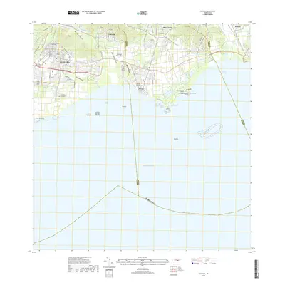
2018 Map of Guayama
USGS Topo · Published 2018About this map
Guayama and its coastal neighbors define this Southern Puerto Rico landscape, where the urban grid meets the Caribbean Sea. The region is marked by a complex network of waterways, including the Canal de Guamaní Este and the Río Guamaní, which supported the historical agricultural and civil development of the coastal plain. Significant local infrastructure is evident in the multiple burial grounds serving the population, such as the Cementerio Municipal Viejo de Guayama and the newer Cementerio Municipal Nuevo de Guayama. Along the shoreline, the importance of maritime and recreational life is highlighted by features like Puerto Arroyo and the Punta Guilarte Beach. The inland hills rise toward Monte Brujo, framing the northern edge of settlements like Olimpo and Corazón as they transition from the alluvial flats to the rugged interior.
Find a feature on this map
39 named features on this map. Tap any name to fly to it.
Don’t see what you’re looking for? This feature index may not catch every label — zoom into the map to look around manually.
Map Details
Editions of this 2018 Guayama Map
This is the sole edition of this map. No revisions or reprints were ever made.
Other maps of this area

1945 · Punta Tuna
USGS Topo · 1:30,000

1945 · Central Aguirre
USGS Topo · 1:30,000

1946 · Patillas
USGS Topo · 1:30,000

1946 · Cayey
USGS Topo · 1:30,000

1946 · Yabucoa
USGS Topo · 1:30,000

1946 · Guayama
USGS Topo · 1:30,000

1947 · Yabucoa SO
USGS Topo · 1:10,000

1947 · Patillas SO
USGS Topo · 1:10,000
1947 · Guayama NE
USGS Topo · 1:10,000
1947 · Punta Tuna NO
USGS Topo · 1:10,000