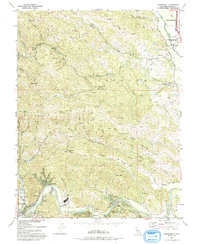
1993 Map of Guerneville
USGS Topo · Published 1993About this map
The Russian River carves a winding path through this portion of Sonoma County, defining the development of resort communities and small settlements along its banks. By the early 1990s, towns like Guerneville, Rio Nido, and Hacienda show a dense concentration of structures tucked into the river valley, while the surrounding uplands remain dominated by steep ridges and protected lands. The Armstrong Redwoods State Reserve stands as a significant natural landmark to the north, contrasting with industrial and resource-based sites like the Sopoma Mine near Sweetwater Creek. Historical educational and social sites are scattered throughout the hills, including the Daniels School (Aband) and Camp Rosenberg, illustrating the area's transition from early timber and mining efforts to a landscape increasingly shaped by recreation and small-scale agriculture. The network of winding roads, including Mill Creek Road and Westside Road, follows the natural drainage patterns of Porter Creek and Mill Creek, connecting the river towns to the Healdsburg corporate boundary.
Find a feature on this map
61 named features on this map. Tap any name to fly to it.
Don’t see what you’re looking for? This feature index may not catch every label — zoom into the map to look around manually.
Map Details
Editions of this 1993 Guerneville Map
This is the sole edition of this map. No revisions or reprints were ever made.
Other maps of this area

1920 · Healdsburg
USGS Topo · 1:62,500

1921 · Skaggs
USGS Topo · 1:62,500

1933 · Healdsburg
USGS Topo · 1:48,000

1935 · Sebastopol
USGS Topo · 1:48,000

1940 · Healdsburg
USGS Topo · 1:62,500

1942 · Sebastopol
USGS Topo · 1:62,500

1943 · Cazadero
USGS Topo · 1:24,000

1943 · Duncans Mills
USGS Topo · 1:24,000

1943 · Skaggs Springs
USGS Topo · 1:24,000

1944 · Skaggs Springs
USGS Topo · 1:31,680