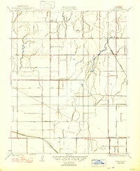
1929 Map of Guernsey
USGS Topo · Published 1949About this map
Mussel Slough and a complex network of irrigation channels define this San Joaquin Valley landscape during the late 1920s. The settlement of Guernsey serves as a small rail hub along the Atchison Topeka and Santa Fe railroad, situated at the junction of Clark Slough and Guernsey Slough. The area's transition from a natural marshland to an engineered agricultural plain is evident in the grid of man-made waterways like the Last Chance Ditch, New Deal Canal, and Tulare Lake Canal. This map reveals a distributed rural community supported by local institutions, including Paddock Sch, Frazer Sch, and New Home Sch. The concentration of these schoolhouses suggests a once-active population density before modern agricultural consolidation shifted the local demographics. Water management is the primary driver of the terrain, as seen in the diverse naming of ditches and canals like the Peoples Ditch and Chamberlain Canal that crisscross the flat valley floor.
Find a feature on this map
23 named features on this map. Tap any name to fly to it.
Don’t see what you’re looking for? This feature index may not catch every label — zoom into the map to look around manually.
Map Details
Editions of this 1929 Guernsey Map
2 editions found
Other maps of this area

1926 · Hanford
USGS Topo · 1:31,680

1927 · Remnoy
USGS Topo · 1:31,680

1927 · Lemoore
USGS Topo · 1:31,680

1928 · Waukena
USGS Topo · 1:31,680

1928 · Corcoran
USGS Topo · 1:31,680

1929 · Guernsey
USGS Topo · 1:31,680

1929 · Stratford
USGS Topo · 1:31,680

1932 · El Rico Ranch
USGS Topo · 1:31,680

1933 · Chatom Ranch
USGS Topo · 1:31,680
1935 · Chatom Ranch
USGS Topo · 1:31,680