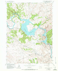
1971 Map of Guernsey Reservoir
USGS Topo · Published 1972About this map
The North Platte River winds through the Platte County landscape, dominated here by the waters of the Guernsey Reservoir. This 1971 revision of earlier surveys captures the layered history of the area, from the pioneer tracks of the Emigrant Trail to the infrastructure of the Burlington Northern railroad. The presence of the Lucinda Rollins Grave and an Oregon Trail Marker near the Frederick Ranch highlights the deep connection to westward expansion that still defined the terrain in the mid-20th century.
Find a feature on this map
42 named features on this map. Tap any name to fly to it.
Don’t see what you’re looking for? This feature index may not catch every label — zoom into the map to look around manually.
Map Details
Editions of this 1971 Guernsey Reservoir Map
This is the sole edition of this map. No revisions or reprints were ever made.
Other maps of this area

1896 · Hartville
USGS Topo · 1:125,000

1901 · Hartville
USGS Topo · 1:125,000

1950 · Guernsey
USGS Topo · 1:24,000

1950 · Herman Ranch
USGS Topo · 1:24,000

1950 · Register Cliff
USGS Topo · 1:24,000

1950 · Haushar Ranch
USGS Topo · 1:24,000

1950 · Hell Gap
USGS Topo · 1:24,000

1950 · Guernsey Reservoir
USGS Topo · 1:24,000

1951 · Haushar Ranch
USGS Topo · 1:24,000

1951 · Guernsey Reservoir
USGS Topo · 1:24,000