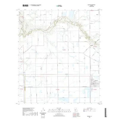
2020 Map of Gueydan
USGS Topo · Published 2020About this map
Gueydan anchors the southeastern corner of this survey, where a rigid grid of town streets like Henri Gueydan St and Daspit St gives way to the vast agricultural irrigation networks of Vermilion Parish. The landscape is defined by the winding course of Bayou Queue de Tortue, which serves as a natural boundary between Acadia and Vermilion Parishes. To the north, the small settlement of Riceville sits near the Mermentau River, while the rural expanse is dotted with private aviation sites like Venissat Airstrip. The surveying reveals a highly managed water system, utilizing the Moon Island Canal and Lazy Point Canal to navigate the low-lying terrain. Local history is preserved at the Istre Cem, situated among a network of rural roads named for local wildlife and landmarks, including Shark Rd and Pelican Rd.
Find a feature on this map
85 named features on this map. Tap any name to fly to it.
Don’t see what you’re looking for? This feature index may not catch every label — zoom into the map to look around manually.
Map Details
Editions of this 2020 Gueydan Map
This is the sole edition of this map. No revisions or reprints were ever made.
Other maps of this area

1946 · Morse
USGS Topo · 1:31,680

1946 · Lake Arthur
USGS Topo · 1:31,680

1946 · Schooner Bayou NW
USGS Topo · 1:31,680

1946 · Mermentau
USGS Topo · 1:31,680

1946 · Jennings
USGS Topo · 1:31,680

1949 · Gueydan
USGS Topo · 1:31,680

1949 · Estherwood
USGS Topo · 1:31,680

1952 · Lake Charles
USGS Topo · 1:250,000

1954 · Grand Lake East NW
USGS Topo · 1:31,680
1954 · Schooner Bayou NW
USGS Topo · 1:31,680