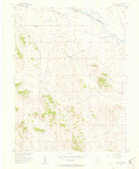
1956 Map of Guffey NW
USGS Topo · Published 1957About this map
The South Platte River and its complex irrigation network define the northeastern corner of this Park County landscape. Extensive water management for the Missouri River Basin development is evident through the presence of the Western Ditch, Central Ditch, and Flume Ditch, alongside an Old Railroad Grade that speaks to earlier transport corridors.
Find a feature on this map
13 named features on this map. Tap any name to fly to it.
Don’t see what you’re looking for? This feature index may not catch every label — zoom into the map to look around manually.
Map Details
Editions of this 1956 Guffey NW Map
2 editions found
Other maps of this area

1953 · Denver
USGS Topo · 1:250,000

1954 · Pueblo
USGS Topo · 1:250,000

1956 · Sulphur Mountain
USGS Topo · 1:24,000

1956 · Antero Reservoir NE
USGS Topo · 1:24,000

1956 · Hartsel
USGS Topo · 1:24,000

1956 · Guffey NW
USGS Topo · 1:24,000

1956 · Glentivar
USGS Topo · 1:24,000

1956 · Spinney Mountain
USGS Topo · 1:24,000

1957 · Denver
USGS Topo · 1:250,000

1957 · Pueblo
USGS Topo · 1:250,000