1956 Map of Spinney Mountain
USGS Topo · Published 1958About this map
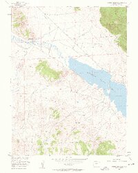
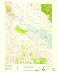
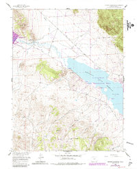
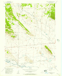
The South Platte River winds through the high-altitude basin of Park County in this mid-century survey, just as the landscape was being reshaped by water management projects. The massive Elevenmile Canyon Reservoir dominates the eastern half of the map, held back by a spillway at 8,561 feet. Cattle ranching heritage is central to this area, represented by the distinct Hartsel Ranch (Lower Spinney Unit) and Hartsel Ranch (Rogers Unit) located near the river and Pruden Mountain.
Find a feature on this map
20 named features on this map. Tap any name to fly to it.
Don’t see what you’re looking for? This feature index may not catch every label — zoom into the map to look around manually.
Map Details
Editions of this 1956 Spinney Mountain Map
3 editions found
Other maps of this area

1893 · Platte Canyon
USGS Topo · 1:125,000

1894 · Pikes Peak
USGS Topo · 1:125,000

1901 · Pikes Peak
USGS Topo · 1:125,000

1953 · Denver
USGS Topo · 1:250,000

1954 · Pueblo
USGS Topo · 1:250,000
1956 · Tarryall
USGS Topo · 1:24,000
1956 · Sulphur Mountain
USGS Topo · 1:24,000
1956 · Elevenmile Canyon
USGS Topo · 1:24,000
1956 · Guffey NW
USGS Topo · 1:24,000
1956 · Glentivar
USGS Topo · 1:24,000