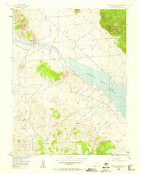
1956 Map of Spinney Mountain
USGS Topo · Published 1958About this map
The South Platte River winds through the high-altitude landscape of Park County in the mid-1950s, feeding into the expansive Elevenmile Canyon Reservoir. This survey highlights the region's ranching heritage, specifically detailing the Hartsel Ranch (Lower Spinney Unit) and the Hartsel Ranch (Rogers Unit), which sit at the base of Spinney Mtn. A significant piece of transportation history is visible in the Old Railroad Grade, tracing a defunct path through the river valley west of the reservoir. The map documents an environment shaped by water management and grazing, with numerous drainages like Threemile Creek, Pruden Creek, and Boyer Gulch cutting through the foothills. Portions of the Pike National Forest flank the eastern and southern edges, anchored by the prominent Stoll Mountain. Local transit is represented by the winding Thirtynine Mile Road, which provides access to the rugged southeastern terrain.
Find a feature on this map
21 named features on this map. Tap any name to fly to it.
Don’t see what you’re looking for? This feature index may not catch every label — zoom into the map to look around manually.
Map Details
Editions of this 1956 Spinney Mountain Map
3 editions found

Other maps of this area

1893 · Platte Canyon
USGS Topo · 1:125,000

1894 · Pikes Peak
USGS Topo · 1:125,000

1901 · Pikes Peak
USGS Topo · 1:125,000

1953 · Denver
USGS Topo · 1:250,000

1954 · Pueblo
USGS Topo · 1:250,000

1956 · Tarryall
USGS Topo · 1:24,000

1956 · Sulphur Mountain
USGS Topo · 1:24,000

1956 · Elevenmile Canyon
USGS Topo · 1:24,000

1956 · Guffey NW
USGS Topo · 1:24,000

1956 · Glentivar
USGS Topo · 1:24,000