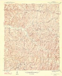
1947 Map of Guinn Cross Roads
USGS Topo · Published 1947About this map
Little Bear Creek and Bear Creek carve deep, winding paths through the hills of Franklin County, defining the landscape of this post-war Alabama survey. The settlement patterns follow the ridges and creek valleys, centered on small hubs like Guinn Cross Roads and Dempsey. The map is particularly rich in genealogical data, documenting numerous family and community landmarks such as Bolin Cem, Macedonia Cem, and Baggett Cem. These rural anchors, alongside Bradley Chapel and Sparks Ch, illustrate the social fabric of the era. The terrain is marked by significant natural features and early industry, including the Sartin Mill on Hurricane Creek and the dramatic Jacobs Ladder Bluff overlooking the river bends. The intricate network of hollows, such as Scott Hollow and Pierce Hollow, reveals the complex drainage system of the Tennessee River valley before modern development significantly altered the rural character.
Find a feature on this map
61 named features on this map. Tap any name to fly to it.
Don’t see what you’re looking for? This feature index may not catch every label — zoom into the map to look around manually.
Map Details
Editions of this 1947 Guinn Cross Roads Map
2 editions found
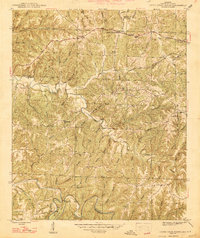
Other maps of this area

1925 · Barton
USGS Topo · 1:62,500

1926 · Barton
USGS Topo · 1:48,000

1929 · Barton
USGS Topo · 1:62,500

1935 · Pleasant Site
USGS Topo · 1:24,000

1936 · Frankfort
USGS Topo · 1:24,000

1936 · Pleasant Grove
USGS Topo · 1:24,000

1936 · Hodges
USGS Topo · 1:24,000

1936 · Isbell
USGS Topo · 1:24,000

1936 · Hackleburg
USGS Topo · 1:24,000

1936 · Vina
USGS Topo · 1:24,000