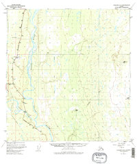
1949 Map of Gulkana A-3
USGS Topo · Published 1977About this map
The Copper River forms the central spine of this landscape, carving a wide valley through the interior of the territory at a time of significant infrastructure development. In the mid-twentieth century, this corridor served as a vital junction for the Richardson Highway and the Glenn Highway, which met near the roadside stop at Gateway Lodge. The presence of the Trans-Alaska Pipeline running parallel to the river reflects the modernization of the Alaskan interior, even as the surrounding terrain remained dominated by natural features like the Klawasi River and Mineral Spring. This period of transition is further evidenced by the FAA Station at the Gulkana Airport, which highlights the increasing importance of air travel for remote northern communities. Land surveyors and pilots of the era relied on prominent landmarks such as VABM 3017 Klawasi and the geothermal Klawasi Warm Spring to navigate this riverine environment.
Find a feature on this map
20 named features on this map. Tap any name to fly to it.
Don’t see what you’re looking for? This feature index may not catch every label — zoom into the map to look around manually.
Map Details
Editions of this 1949 Gulkana A-3 Map
4 editions found
Other maps of this area

1948 · Valdez D-5
USGS Topo · 1:63,360

1949 · Gulkana A-3
USGS Topo · 1:63,360

1949 · Valdez D-4
USGS Topo · 1:63,360

1949 · Gulkana B-2
USGS Topo · 1:63,360

1950 · Gulkana B-3
USGS Topo · 1:63,360

1951 · Valdez D-5
USGS Topo · 1:63,360

1951 · Gulkana
USGS Topo · 1:250,000

1951 · Gulkana A-4
USGS Topo · 1:63,360

1951 · Gulkana B-4
USGS Topo · 1:63,360

1952 · Gulkana A-3
USGS Topo · 1:63,360