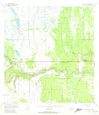
1951 Map of Gulkana A-4
USGS Topo · Published 1972About this map
The Glenn Highway serves as the primary artery through this interior Alaskan landscape, connecting isolated outposts and lodges during the early 1950s. The settlement of Glennallen sits at a critical junction in the east, supported by local establishments like the Glennallen Lodge and the I Bar F Lodge. The topography is defined by the winding course of the Tazlina River, which cuts through the southern portion of the quadrangle, fed by tributaries such as Moose Creek, Nickel Creek, and Durham Creek.
Find a feature on this map
15 named features on this map. Tap any name to fly to it.
Don’t see what you’re looking for? This feature index may not catch every label — zoom into the map to look around manually.
Map Details
Editions of this 1951 Gulkana A-4 Map
2 editions found

Other maps of this area

1948 · Valdez D-5
USGS Topo · 1:63,360

1949 · Gulkana A-3
USGS Topo · 1:63,360

1949 · Gulkana A-5
USGS Topo · 1:63,360

1949 · Valdez D-4
USGS Topo · 1:63,360

1949 · Valdez D-6
USGS Topo · 1:63,360

1950 · Gulkana B-3
USGS Topo · 1:63,360

1951 · Valdez D-5
USGS Topo · 1:63,360

1951 · Gulkana
USGS Topo · 1:250,000

1951 · Valdez D-6
USGS Topo · 1:63,360

1951 · Gulkana B-5
USGS Topo · 1:63,360