
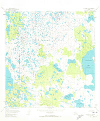
1951 Map of Gulkana B-5
USGS Topo · Published 1960About this map
Crosswind Lake (Charley Lake) dominates the eastern landscape of this Copper River Meridian region, captured during a period when the area remained largely roadless. The terrain is defined by a dense network of small water bodies and marshlands, including Bell Lake, Y Lake, and Deep Lake. Local high points are marked by First Hill and Second Hill, which sit adjacent to their namesake First Hill Lake and Second Hill Lake 32. Human presence is sparse, indicated primarily by isolated Cabins and a Landing Strip near the northeastern shore of Crosswind Lake. The drainage patterns are anchored by Tolsona Creek and the expansive Lake Louise in the southwest corner. This survey reflects the remote character of interior Alaska in the early 1950s, where movement relied heavily on bush planes and traditional water routes through the complex lake systems.
Find a feature on this map
15 named features on this map. Tap any name to fly to it.
Don’t see what you’re looking for? This feature index may not catch every label — zoom into the map to look around manually.
Map Details
Editions of this 1951 Gulkana B-5 Map
2 editions found
Other maps of this area

1949 · Gulkana A-5
USGS Topo · 1:63,360

1949 · Gulkana A-6
USGS Topo · 1:63,360

1950 · Gulkana C-4
USGS Topo · 1:63,360

1950 · Gulkana B-6
USGS Topo · 1:63,360

1951 · Gulkana
USGS Topo · 1:250,000

1951 · Gulkana A-4
USGS Topo · 1:63,360

1951 · Gulkana C-5
USGS Topo · 1:63,360

1951 · Gulkana B-4
USGS Topo · 1:63,360

1951 · Gulkana C-6
USGS Topo · 1:63,360

1952 · Gulkana A-5
USGS Topo · 1:63,360