
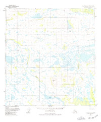
1951 Map of Gulkana C-6
USGS Topo · Published 1974About this map
Tyone Village sits along the northern shore of Tyone Lake, serving as a primary focal point for human activity in this interior Alaskan wilderness during the early 1950s. The landscape is defined by an intricate network of wetlands and waterways, where the Tyone River meanders through low-lying terrain before meeting the lake. To the north, the West Fork Gulkana River and Moose Cr drain the higher elevations, providing a clear picture of the region's complex drainage patterns. The topography is anchored by surveyed high points like VABM 3537 Tyone and VABM 2680 Wonderly, which rise above the surrounding flats. This survey, compiled from 1950 aerial photography, captures a remote area where settlement was sparse and largely tied to the natural water systems and traditional landing sites.
Find a feature on this map
7 named features on this map. Tap any name to fly to it.
Don’t see what you’re looking for? This feature index may not catch every label — zoom into the map to look around manually.
Map Details
Editions of this 1951 Gulkana C-6 Map
2 editions found
Other maps of this area

1950 · Talkeetna Mountains
USGS Topo · 1:250,000

1950 · Gulkana B-6
USGS Topo · 1:63,360

1951 · Gulkana
USGS Topo · 1:250,000

1951 · Gulkana D-6
USGS Topo · 1:63,360

1951 · Talkeetna Mountains B-1
USGS Topo · 1:63,360

1951 · Gulkana B-5
USGS Topo · 1:63,360

1951 · Gulkana D-5
USGS Topo · 1:63,360

1951 · Gulkana C-5
USGS Topo · 1:63,360

1951 · Talkeetna Mountains C-1
USGS Topo · 1:63,360

1951 · Talkeetna Mountains D-1
USGS Topo · 1:63,360