
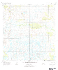
1951 Map of Gulkana C-5
USGS Topo · Published 1963About this map
The West Fork Gulkana River winds through a dense landscape of thermokarst lakes and wetlands in this 1951 study of the Alaska interior. The terrain is defined by an intricate network of hundreds of unnamed small lakes and ponds, characteristic of the permafrost-heavy regions of the Copper River Basin. While the map shows no roads or trails, it documents vital drainage systems like Moose Creek and Keg Creek as they feed into the larger river system. A singular geodetic marker, VABM 3129 Bragg, provides a fixed elevation point in an otherwise undulating expanse of marsh and muskeg. Published by the Geological Survey with land lines predetermined by the Bureau of Land Management, the map captures the area in its raw, unsurveyed state before significant modern infrastructure reached this portion of the Matanuska-Susitna region.
Find a feature on this map
4 named features on this map. Tap any name to fly to it.
Don’t see what you’re looking for? This feature index may not catch every label — zoom into the map to look around manually.
Map Details
Editions of this 1951 Gulkana C-5 Map
2 editions found
Other maps of this area

1950 · Gulkana D-4
USGS Topo · 1:63,360

1950 · Gulkana C-4
USGS Topo · 1:63,360

1950 · Gulkana B-6
USGS Topo · 1:63,360

1951 · Gulkana
USGS Topo · 1:250,000

1951 · Gulkana D-6
USGS Topo · 1:63,360

1951 · Gulkana B-5
USGS Topo · 1:63,360

1951 · Gulkana D-5
USGS Topo · 1:63,360

1951 · Gulkana B-4
USGS Topo · 1:63,360

1951 · Gulkana C-6
USGS Topo · 1:63,360

1952 · Gulkana D-4
USGS Topo · 1:63,360