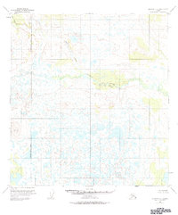
1951 Map of Gulkana C-5
USGS Topo · Published 1984About this map
The West Fork Gulkana River dominates this mid-century survey of the interior, meandering through a landscape defined by extensive wetlands and glacial features. Recorded by the Geological Survey from aerial photography taken in 1950, the map illustrates the complex drainage patterns of the Matanuska-Susitna Borough boundary. In the northern reaches, the terrain is shaped by the descent of Moose Creek and Keg Creek, while the high point at VABM 3129 Bragg serves as a primary survey marker for the region. This is a landscape of transition, showing the river before more modern infrastructure altered the accessibility of the Alaskan wilderness. The presence of numerous unnamed lakes and ponds alongside the river's main channel highlights the intricate hydrology of the Gulkana basin during this era.
Find a feature on this map
5 named features on this map. Tap any name to fly to it.
Don’t see what you’re looking for? This feature index may not catch every label — zoom into the map to look around manually.
Map Details
Editions of this 1951 Gulkana C-5 Map
2 editions found
Other maps of this area

1950 · Gulkana D-4
USGS Topo · 1:63,360

1950 · Gulkana C-4
USGS Topo · 1:63,360

1950 · Gulkana B-6
USGS Topo · 1:63,360

1951 · Gulkana
USGS Topo · 1:250,000

1951 · Gulkana D-6
USGS Topo · 1:63,360

1951 · Gulkana B-5
USGS Topo · 1:63,360

1951 · Gulkana D-5
USGS Topo · 1:63,360

1951 · Gulkana C-5
USGS Topo · 1:63,360

1951 · Gulkana B-4
USGS Topo · 1:63,360

1951 · Gulkana C-6
USGS Topo · 1:63,360