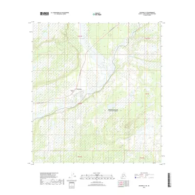
2019 Map of Gulkana C-2 SE
USGS Topo · Published 2019About this map
The settlement of Chistochina sits at a strategic junction in the Copper River Basin, where the Tok Cutoff Highway meets the braided channels of the Chistochina River. This 2019 survey illustrates the vital transportation corridor connecting the interior with the coast, supported by the Chistochina Airport. The landscape is dominated by the massive confluence where the Chistochina flows into the Copper River, a complex network of gravel bars and shifting watercourses. To the south and east, the map detail extends into the protected wilderness of the Wrangell-St. Elias National Preserve, showcasing a terrain defined by glacial runoff and tributary streams like Boulder Creek and Simona Cr. The layout of surveyed townships, including t9n r4e and t10n r4e, reveals the limited but essential footprint of human infrastructure within this expansive northern environment.
Find a feature on this map
14 named features on this map. Tap any name to fly to it.
Don’t see what you’re looking for? This feature index may not catch every label — zoom into the map to look around manually.
Map Details
Editions of this 2019 Gulkana C-2 SE Map
This is the sole edition of this map. No revisions or reprints were ever made.
Other maps of this area

1949 · Gulkana C-2
USGS Topo · 1:63,360

1949 · Gulkana B-2
USGS Topo · 1:63,360

1949 · Gulkana C-1
USGS Topo · 1:63,360

1951 · Gulkana
USGS Topo · 1:250,000

1952 · Gulkana B-2
USGS Topo · 1:63,360

1952 · Gulkana C-2
USGS Topo · 1:63,360

1952 · Gulkana C-1
USGS Topo · 1:63,360

1959 · Gulkana B-1
USGS Topo · 1:63,360

1959 · Gulkana
USGS Topo · 1:250,000

1965 · Gulkana
USGS Topo · 1:250,000