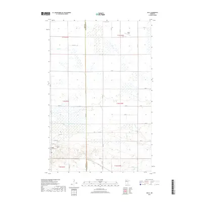
2019 Map of Gully
USGS Topo · Published 2019About this map
The village of Gully anchors the southwestern corner of this survey, where the local landscape transitions from organized agricultural plots to the expansive wetlands characteristic of northwestern Minnesota. Life in this rural corridor is centered around the small settlement and its community landmarks, including the Lund Lutheran Cem situated just outside the town limits. Further north, the Oak Grove Cem and Mathis Airport sit near the boundary line between Polk Co and Clearwater Co. The hydrology of the region is defined by the winding path of the Lost River and the engineered precision of the County Ditch Number Eighty-nine, illustrating the historical efforts to manage the prairie’s high water table for farming. A grid of county roads, such as Co Hwy 48 and Co Rd 7, provides the primary framework for movement between these remote farmsteads and township sections.
Find a feature on this map
31 named features on this map. Tap any name to fly to it.
Don’t see what you’re looking for? This feature index may not catch every label — zoom into the map to look around manually.
Map Details
Editions of this 2019 Gully Map
This is the sole edition of this map. No revisions or reprints were ever made.
Other maps of this area
1919 · Fosston
USGS Topo · 1:62,500
1919 · Churnes
USGS Topo · 1:62,500
1919 · Winsor
USGS Topo · 1:62,500
1943 · Bagley
USGS Topo · 1:62,500

1954 · Bemidji
USGS Topo · 1:250,000

1957 · Bemidji
USGS Topo · 1:250,000

1958 · Bemidji
USGS Topo · 1:250,000
1969 · Olga
USGS Topo · 1:24,000
1969 · Clearbrook
USGS Topo · 1:24,000
1969 · Gonvick
USGS Topo · 1:24,000