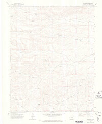
1971 Map of Gulnare
USGS Topo · Published 1973About this map
The Gulnare settlement and the winding Apishapa River characterize this 1971 topographical study of the Colorado landscape. Located in Las Animas County, the area features a network of complex drainages, including Jarosa Canyon and Trujillo Canyon, which historically dictated the paths of local travel and settlement. The southern portion of the map is dominated by the Spanish Peaks State Wildlife Area, where the terrain ascends toward Cottontail Pass. For local history researchers and genealogists, the inclusion of the Jarosa Cem and another smaller Cem offers specific locations for tracing early families in this ranching and wildlife corridor. The map's detailed hydrology, from Mitotes Lake to the various forks of the river, illustrates the critical importance of water management in this arid environment.
Find a feature on this map
25 named features on this map. Tap any name to fly to it.
Don’t see what you’re looking for? This feature index may not catch every label — zoom into the map to look around manually.
Map Details
Editions of this 1971 Gulnare Map
4 editions found
Other maps of this area

1891 · Spanish Peaks
USGS Topo · 1:125,000

1893 · Spanish Peaks
USGS Topo · 1:125,000

1895 · Spanish Peaks
USGS Topo · 1:125,000

1897 · Spanish Peaks
USGS Topo · 1:125,000

1900 · Spanish Peaks
USGS Topo · 1:125,000

1951 · Madrid
USGS Topo · 1:24,000

1954 · Trinidad
USGS Topo · 1:250,000

1955 · Trinidad
USGS Topo · 1:250,000

1958 · Trinidad
USGS Topo · 1:250,000

1959 · Trinidad
USGS Topo · 1:250,000