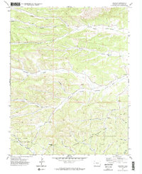
1971 Map of Gulnare
USGS Topo · Published 1974About this map
Gulnare sits at the convergence of several major drainage systems in Las Animas County, where the Apishapa River meets a network of steep canyons and high-altitude terrain. The landscape is defined by the sharp verticality of the Spanish Peaks State Wildlife Area, an area marked by numerous Jeep trails and family-named landmarks like Trujillo Creek Canyon and Mitotes Canyon.
Find a feature on this map
29 named features on this map. Tap any name to fly to it.
Don’t see what you’re looking for? This feature index may not catch every label — zoom into the map to look around manually.
Map Details
Editions of this 1971 Gulnare Map
4 editions found
Other maps of this area

1891 · Spanish Peaks
USGS Topo · 1:125,000

1893 · Spanish Peaks
USGS Topo · 1:125,000

1895 · Spanish Peaks
USGS Topo · 1:125,000

1897 · Spanish Peaks
USGS Topo · 1:125,000

1900 · Spanish Peaks
USGS Topo · 1:125,000

1951 · Madrid
USGS Topo · 1:24,000

1954 · Trinidad
USGS Topo · 1:250,000

1955 · Trinidad
USGS Topo · 1:250,000

1958 · Trinidad
USGS Topo · 1:250,000

1959 · Trinidad
USGS Topo · 1:250,000