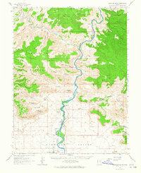
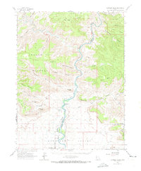
1963 Map of Gunnison Butte
USGS Topo · Published 1965About this map
Green River flows south through the heart of the Green River Valley, carving a path through the dramatic Book Cliffs and past the distinctive Gunnison Butte. This early 1960s survey captures the junction where the Price River meets the Green, a landscape defined by sharp elevations like the Beckwith Plateau and Elliott Mesa. The mapping reveals a mix of irrigation infrastructure and early industrial markers, such as the Diversion Dam Spillway and a Gravel Pit near a siphon.
Find a feature on this map
47 named features on this map. Tap any name to fly to it.
Don’t see what you’re looking for? This feature index may not catch every label — zoom into the map to look around manually.
Map Details
Editions of this 1963 Gunnison Butte Map
2 editions found
Other maps of this area

1885 · San Rafael
USGS Topo · 1:250,000

1885 · East Tavaputs
USGS Topo · 1:250,000

1885 · La Sal
USGS Topo · 1:250,000

1886 · Price River
USGS Topo · 1:250,000

1896 · Price River
USGS Topo · 1:250,000

1948 · Woodside
USGS Topo · 1:62,500

1949 · Woodside
USGS Topo · 1:62,500

1950 · Woodside
USGS Topo · 1:62,500
1954 · Tidwell 1 NE
USGS Topo · 1:24,000
1954 · Tidwell 2 NE
USGS Topo · 1:24,000