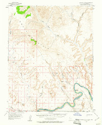
1953 Map of Gunsight Butte
USGS Topo · Published 1961About this map
The Crossing of the Fathers marks a significant historical point along the Colorado River in this mid-century survey of the Utah-Arizona borderlands. Before the landscape was transformed by the filling of Lake Powell, the river flowed freely through Glen Canyon, flanked by the Rainbow Plateau and the Navajo Indian Reservation. The map captures a complex drainage system where Last Chance Creek, Kane Wash, and Navajo Padre Canyon converge toward the river's path. High ground is dominated by the massive Smoky Mountain and prominent landmarks like Gunsight Butte and Castle Rock. This survey provides a rare look at the original riverbed and its surrounding canyons as they appeared just years before the construction of the Glen Canyon Dam, documenting a geography that is now largely submerged.
Find a feature on this map
30 named features on this map. Tap any name to fly to it.
Don’t see what you’re looking for? This feature index may not catch every label — zoom into the map to look around manually.
Map Details
Editions of this 1953 Gunsight Butte Map
3 editions found
Other maps of this area

1886 · Escalante
USGS Topo · 1:250,000

1886 · Echo Cliffs
USGS Topo · 1:250,000

1891 · Echo Cliffs
USGS Topo · 1:250,000

1922 · Warm Creek
USGS Topo · 1:63,360

1922 · Upper Last Chance
USGS Topo · 1:63,360

1922 · Rees Canyon
USGS Topo · 1:63,360

1951 · Lees Ferry NE
USGS Topo · 1:24,000

1953 · Cummings Mesa
USGS Topo · 1:62,500

1953 · Nipple Butte
USGS Topo · 1:62,500

1953 · Gunsight Butte
USGS Topo · 1:62,500