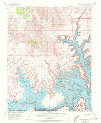
1953 Map of Gunsight Butte
USGS Topo · Published 1972About this map
Lake Powell dominates the lower half of this landscape, its waters reaching deep into the jagged drainages of the Glen Canyon National Recreation Area. The topography is defined by massive sandstone formations and expansive plateaus, including Smoky Mountain and the Grand Bench. This mid-century survey captures the region as the newly formed reservoir began to fill the canyons, reflecting the radical change from the original Colorado River corridor to a sprawling lacustrine environment. Significant landmarks such as Gunsight Butte and Castle Rock rise above the high-water mark, while various inlets like Last Chance Bay and Gunsight Bay trace the drowned paths of ancient creeks. To the south, the Navajo Indian Reservation boundary follows the river's original course, marking the intersection of federal recreation lands and tribal territory across the Rainbow Plateau.
Find a feature on this map
42 named features on this map. Tap any name to fly to it.
Don’t see what you’re looking for? This feature index may not catch every label — zoom into the map to look around manually.
Map Details
Editions of this 1953 Gunsight Butte Map
3 editions found
Other maps of this area

1886 · Escalante
USGS Topo · 1:250,000

1886 · Echo Cliffs
USGS Topo · 1:250,000

1891 · Echo Cliffs
USGS Topo · 1:250,000

1922 · Warm Creek
USGS Topo · 1:63,360

1922 · Upper Last Chance
USGS Topo · 1:63,360

1922 · Rees Canyon
USGS Topo · 1:63,360

1951 · Lees Ferry NE
USGS Topo · 1:24,000

1953 · Cummings Mesa
USGS Topo · 1:62,500

1953 · Nipple Butte
USGS Topo · 1:62,500

1953 · Gunsight Butte
USGS Topo · 1:62,500