1967 Map of Gunsight Canyon
USGS Topo · Published 1979About this map
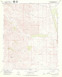
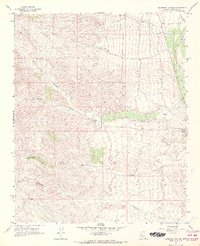
Big Sandy River cuts through the eastern edge of this landscape, defining a low-lying valley that contrasts with the intricate drainage networks to the west. This 1960s topographic survey illustrates an arid environment where water management is critical for land use, evidenced by scattered Water Tanks and a solitary Corral positioned near the basin floor. The terrain is dominated by deep seasonal channels, most notably Gunsight Canyon and Tompkins Canyon, which drain the elevated western interior toward the river. Resource extraction and movement are marked by a Prospect and a Borrow Pit, while a network of Jeep Trails provides the primary access through the complex washes. The mapping of Crow Canyon Wash and Deluge Wash highlights the natural corridors that historically dictated travel and ranching patterns in this section of Mohave County.
Find a feature on this map
19 named features on this map. Tap any name to fly to it.
Don’t see what you’re looking for? This feature index may not catch every label — zoom into the map to look around manually.
Map Details
Editions of this 1967 Gunsight Canyon Map
2 editions found
Other maps of this area

1923 · Signal
USGS Topo · 1:250,000

1942 · Signal
USGS Topo · 1:250,000

1950 · Prescott
USGS Topo · 1:250,000

1954 · Prescott
USGS Topo · 1:250,000

1958 · Prescott
USGS Topo · 1:250,000

1959 · Prescott
USGS Topo · 1:250,000

1960 · Prescott
USGS Topo · 1:250,000

1965 · Prescott
USGS Topo · 1:250,000
1967 · Gunsight Canyon
USGS Topo · 1:24,000
1967 · Beecher Canyon
USGS Topo · 1:24,000