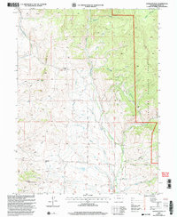
2000 Map of Gunsight Pass
USGS Topo · Published 2004About this map
Gunsight Pass serves as a prominent high-altitude crossing in this Grand County landscape, where the headwaters of several drainages begin their descent. The high-elevation terrain is defined by the sharp divide between Antelope Creek and the vast watershed of Troublesome Creek, including its East Fork. Human intervention in this complex environment is evidenced by a network of water management features, specifically the Pickering Ditch, Missouri Ditch, and Kirtz Ditch, which redirect snowmelt and runoff through the gulches.
Find a feature on this map
25 named features on this map. Tap any name to fly to it.
Don’t see what you’re looking for? This feature index may not catch every label — zoom into the map to look around manually.
Map Details
Editions of this 2000 Gunsight Pass Map
This is the sole edition of this map. No revisions or reprints were ever made.
Other maps of this area

1954 · Craig
USGS Topo · 1:250,000

1956 · Kremmling
USGS Topo · 1:62,500

1956 · Parkview Mountain
USGS Topo · 1:24,000

1956 · Whiteley Peak
USGS Topo · 1:24,000

1956 · Hyannis Peak
USGS Topo · 1:24,000

1956 · Hyannis Peak
USGS Topo · 1:62,500

1956 · Rand
USGS Topo · 1:62,500

1957 · Craig
USGS Topo · 1:250,000

1957 · Hot Sulphur Springs
USGS Topo · 1:62,500

1958 · Craig
USGS Topo · 1:250,000