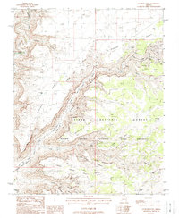
1988 Map of Gunsight Point
USGS Topo · Published 1988About this map
Kaibab National Forest and the Grand Canyon National Game Preserve dominate this high-desert plateau landscape, where deep canyons and prominent points define the topography. The massive drainage of Kanab Creek carves through the terrain, joined by lateral features like Snake Gulch and Little Spring Canyon. This 1980s provisional map details a wilderness managed for both natural preservation and specific resource extraction, evidenced by the presence of the Pigeon Mine near the head of Pigeon Canyon. Water sources are critical landmarks in this arid environment, recorded here as isolated seeps and improvements such as Rock Spring, Slide Spring, and Gunsight Tank. The map tracks the boundary between Mohave and Coconino counties as it traverses high ridges including Gunsight Point and Pigeon Point.
Find a feature on this map
34 named features on this map. Tap any name to fly to it.
Don’t see what you’re looking for? This feature index may not catch every label — zoom into the map to look around manually.
Map Details
Editions of this 1988 Gunsight Point Map
This is the sole edition of this map. No revisions or reprints were ever made.
Other maps of this area

1886 · Kaibab
USGS Topo · 1:250,000

1953 · Grand Canyon
USGS Topo · 1:250,000

1954 · Fredonia SW
USGS Topo · 1:24,000

1954 · Fredonia
USGS Topo · 1:62,500

1957 · Grand Canyon
USGS Topo · 1:250,000

1957 · Shinarump SW
USGS Topo · 1:24,000
1957 · Shinarump
USGS Topo · 1:62,500

1957 · Jumpup Canyon
USGS Topo · 1:62,500

1958 · Grand Canyon
USGS Topo · 1:250,000

1958 · Big Springs
USGS Topo · 1:62,500