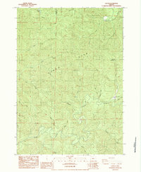
1984 Map of Gunter
USGS Topo · Published 1984About this map
Gunter serves as the primary landmark in this drainage-rich portion of the Oregon Coast Range, where the landscape is defined by the winding paths of the Siuslaw River and Smith River. The area reflects a history shaped by fire and water, most notably marked by the Oxbow Burn and the numerous small lakes and ponds like Esmond Lake and Yellow Lake that dot the timbered ridges. The topography is exceptionally complex, with a dense network of watercourses including North Sister Creek and South Sister Creek cutting through the terrain. Evidence of local industry and community life appears in the small Quarry and a local Cem, providing specific points of interest for those tracing the development of Douglas and Lane counties.
Find a feature on this map
36 named features on this map. Tap any name to fly to it.
Don’t see what you’re looking for? This feature index may not catch every label — zoom into the map to look around manually.
Map Details
Editions of this 1984 Gunter Map
This is the sole edition of this map. No revisions or reprints were ever made.
Other maps of this area

1942 · Crow
USGS Topo · 1:62,500

1942 · Roman Nose Mtn
USGS Topo · 1:62,500

1945 · Crow
USGS Topo · 1:62,500

1945 · Roman Nose Mtn
USGS Topo · 1:62,500

1954 · Drain
USGS Topo · 1:62,500

1955 · Elkton
USGS Topo · 1:62,500

1958 · Roseburg
USGS Topo · 1:250,000

1959 · Roseburg
USGS Topo · 1:250,000

1979 · Cottage Grove
USGS Topo · 1:100,000
1984 · High Point
USGS Topo · 1:24,000