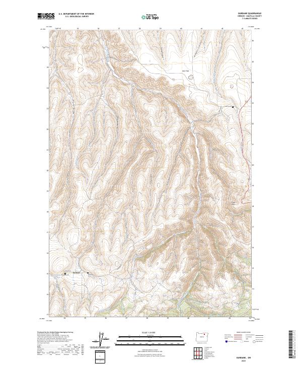
2023 Map of Gurdane
USGS Topo · Published 2023About this map
Gurdane sits at the heart of this high-plateau landscape, where the headwaters of the East Fork Butter Creek and numerous drainages like Alexander Creek and Monahan Creek have carved a complex series of canyons. The geography is defined by these deep natural troughs, including Poat Canyon, Cates Canyon, and Roberts Canyon, which separate high-ground features like Darr Flats.
Find a feature on this map
29 named features on this map. Tap any name to fly to it.
Don’t see what you’re looking for? This feature index may not catch every label — zoom into the map to look around manually.
Map Details
Editions of this 2023 Gurdane Map
This is the sole edition of this map. No revisions or reprints were ever made.
Other maps of this area

1953 · Pendleton
USGS Topo · 1:250,000

1956 · Pendleton
USGS Topo · 1:250,000

1967 · Nye
USGS Topo · 1:24,000

1967 · Carney Butte
USGS Topo · 1:24,000

1967 · Ukiah
USGS Topo · 1:24,000

1968 · Hoodlum Canyon
USGS Topo · 1:24,000

1968 · Gurdane
USGS Topo · 1:24,000
1968 · Vinson
USGS Topo · 1:24,000
1968 · Franklin Hill
USGS Topo · 1:24,000

1969 · Sugarbowl Creek
USGS Topo · 1:24,000