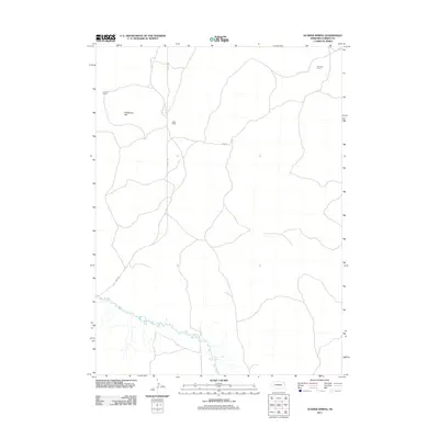
2011 Map of Gusher Spring
USGS Topo · Published 2011About this map
Blue Creek meanders across the southern portion of this high plains landscape in Garden County, marking a vital water source in an otherwise arid expanse. The map reflects a remote ranching economy defined by isolated outposts and named camps rather than concentrated towns. Notable locations such as Holmes Ranch, Wells Camp, and Peterson Camp serve as the primary human landmarks, indicating the distributed nature of settlement in this part of Nebraska. The terrain is characterized by subtle elevation changes and local landmarks like Wildhorse Hill. Local transit is facilitated by a sparse network of unpaved paths, including Rackett Rd and Road 82, which connect these distant ranching operations across the prairie.
Find a feature on this map
8 named features on this map. Tap any name to fly to it.
Don’t see what you’re looking for? This feature index may not catch every label — zoom into the map to look around manually.
Map Details
Editions of this 2011 Gusher Spring Map
This is the sole edition of this map. No revisions or reprints were ever made.
Other maps of this area

1900 · Chappell
USGS Topo · 1:125,000

1949 · Rackett
USGS Topo · 1:62,500

1950 · Crescent Lake
USGS Topo · 1:62,500

1951 · Rackett
USGS Topo · 1:62,500

1954 · Scottsbluff
USGS Topo · 1:250,000

1958 · Scottsbluff
USGS Topo · 1:250,000
1971 · Twin Buttes
USGS Topo · 1:24,000
1971 · Old Baldy
USGS Topo · 1:24,000
1971 · Oshkosh
USGS Topo · 1:24,000
1985 · Chappell
USGS Topo · 1:100,000