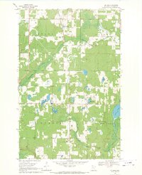
1968 Map of Guthrie
USGS Topo · Published 1971About this map
Guthrie and Nary anchor this Hubbard County landscape during the late 1960s, a region defined by its complex hydrology and the infrastructure of the Northern Pacific railroad. The western edge of Hart Lake and a segment of the upper Mississippi River dominate the eastern boundary, while the interior is threaded with drainage systems like Bungashing Creek and Pokety Creek. For genealogists, the map is particularly rich in local landmarks, including the Guthrie Cemetery, St. Lawrence Cemetery, and Malvik Church with its adjacent cemetery. The map documents a rural transition where localized industry, represented by various Gravel Pits, operated alongside civic centers such as the local Townhall. These features, interspersed among numerous water bodies like Knutson Lake and Horsehead Lake, illustrate the historical settlement patterns of northern Minnesota woods and wetlands.
Find a feature on this map
25 named features on this map. Tap any name to fly to it.
Don’t see what you’re looking for? This feature index may not catch every label — zoom into the map to look around manually.
Map Details
Editions of this 1968 Guthrie Map
2 editions found
Other maps of this area

1954 · Bemidji
USGS Topo · 1:250,000

1957 · Bemidji
USGS Topo · 1:250,000

1958 · Bemidji
USGS Topo · 1:250,000

1968 · Guthrie
USGS Topo · 1:24,000

1968 · Bemidji East
USGS Topo · 1:24,000

1968 · Frontenac Lake
USGS Topo · 1:24,000

1968 · Bemidji West
USGS Topo · 1:24,000

1972 · Benedict
USGS Topo · 1:24,000

1972 · Laporte
USGS Topo · 1:24,000

1972 · Lake George
USGS Topo · 1:24,000