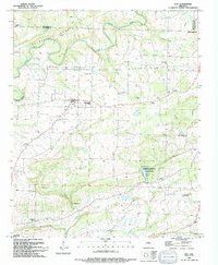
1994 Map of Guy
USGS Topo · Published 1994About this map
Guy stands at the center of this rural Arkansas landscape, where the plateau begins to drop toward the ridges and valleys of the south. The settlement pattern is defined by family-named landmarks and country churches, such as New Home Ch and Fairview Ch, which served the scattered farming communities. In the northern section, the serpentine path of Cadron Creek and its many tributaries, including Batesville Creek and Stillhouse Branch, carve through Batesville Mountain. To the south, the topography becomes more pronounced at The Narrows and Soda Mountain. Recreation and local history converge at Wooley Hollow State Park, which encompasses Bennett Lake and Centerville Park. This survey provides researchers with exact locations for numerous legacy burial grounds, including Copperas Springs Cem, Old Texas Cem, and Mode Cem, reflecting the deep-rooted genealogy of the Faulkner and Van Buren County borderlands.
Find a feature on this map
40 named features on this map. Tap any name to fly to it.
Don’t see what you’re looking for? This feature index may not catch every label — zoom into the map to look around manually.
Map Details
Editions of this 1994 Guy Map
This is the sole edition of this map. No revisions or reprints were ever made.
Other maps of this area

1956 · Russellville
USGS Topo · 1:250,000

1961 · Conway
USGS Topo · 1:62,500

1961 · Bee Branch
USGS Topo · 1:62,500

1961 · Greenbrier
USGS Topo · 1:24,000

1961 · Bee Branch
USGS Topo · 1:24,000

1961 · Morganton
USGS Topo · 1:24,000

1961 · Damascus
USGS Topo · 1:24,000

1961 · Guy
USGS Topo · 1:24,000
1961 · Holland
USGS Topo · 1:24,000

1963 · Quitman
USGS Topo · 1:24,000