
1968 Map of Guymon SE
USGS Topo · Published 1970About this map
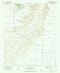
Coldwater Creek carves a winding path through the northern half of this panhandle landscape, marking a sharp transition from the elevated plains of Guymon and Hackberry. By the late 1960s, the region's economy was clearly defined by energy and infrastructure, with numerous Gas Wells and an Oil Well dotting the terrain. A prominent Pipeline cuts across the center, illustrating the mid-century industrial expansion into rural Texas County.
Find a feature on this map
19 named features on this map. Tap any name to fly to it.
Don’t see what you’re looking for? This feature index may not catch every label — zoom into the map to look around manually.
Map Details
Editions of this 1968 Guymon SE Map
This is the sole edition of this map. No revisions or reprints were ever made.
Other maps of this area

1954 · Perryton
USGS Topo · 1:250,000

1958 · Perryton
USGS Topo · 1:250,000

1962 · Hansford Camp
USGS Topo · 1:24,000

1968 · Hardesty
USGS Topo · 1:24,000

1968 · Optima Dam
USGS Topo · 1:24,000

1968 · Guymon
USGS Topo · 1:24,000

1968 · Guymon SW
USGS Topo · 1:24,000

1968 · Guymon NE
USGS Topo · 1:24,000

1974 · Bernstein
USGS Topo · 1:24,000
1974 · Phillips Camp
USGS Topo · 1:24,000