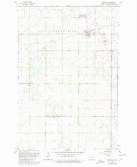
1962 Map of Gwinner
USGS Topo · Published 1980About this map
Gwinner serves as the primary hub of this eastern North Dakota prairie landscape, showing significant development by the late 1970s. The town is situated along the Northern Pacific railroad line, which cuts across the undulating terrain of Whitestone Hill. The map documents the localized growth of the community, featuring a Trailer Park and the Gwinner Municipal Airfield to the east.
Find a feature on this map
9 named features on this map. Tap any name to fly to it.
Don’t see what you’re looking for? This feature index may not catch every label — zoom into the map to look around manually.
Map Details
Editions of this 1962 Gwinner Map
2 editions found
Other maps of this area

1953 · Fargo
USGS Topo · 1:250,000

1956 · Fargo
USGS Topo · 1:250,000

1957 · Stirum
USGS Topo · 1:24,000

1957 · Cogswell
USGS Topo · 1:24,000

1957 · Elliott SE
USGS Topo · 1:24,000

1958 · Rutland
USGS Topo · 1:24,000
1958 · Forman
USGS Topo · 1:24,000

1960 · Lisbon SE
USGS Topo · 1:24,000
1962 · Hoving
USGS Topo · 1:24,000

1962 · Lisbon SW
USGS Topo · 1:24,000