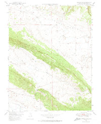
1948 Map of Gypsum Gap
USGS Topo · Published 1974About this map
Dry Creek Basin and the surrounding high-altitude drainage systems dominate this 1948 field-checked survey of San Miguel County. The landscape is defined by the narrow passage of Gypsum Gap, which serves as a natural corridor between the expansive Big Gypsum Valley to the northwest and Disappointment Valley to the south. This era of mapping was influenced by the Atomic Energy Commission, reflecting a period of intense geological scrutiny for mineral resources in the Colorado Plateau.
Find a feature on this map
12 named features on this map. Tap any name to fly to it.
Don’t see what you’re looking for? This feature index may not catch every label — zoom into the map to look around manually.
Map Details
Editions of this 1948 Gypsum Gap Map
4 editions found
Other maps of this area

1916 · Paradox Valley
USGS Topo · 1:125,000

1922 · Paradox Valley
USGS Topo · 1:125,000

1948 · Bull Canyon
USGS Topo · 1:24,000

1948 · Hamm Canyon
USGS Topo · 1:24,000

1948 · Naturita NW
USGS Topo · 1:24,000

1948 · Gypsum Gap
USGS Topo · 1:24,000

1949 · Bull Canyon
USGS Topo · 1:24,000

1949 · Gypsum Gap
USGS Topo · 1:24,000

1949 · Naturita NW
USGS Topo · 1:24,000

1949 · Joe Davis Hill
USGS Topo · 1:24,000