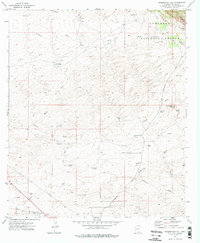
1973 Map of Haberstock Hill
USGS Topo · Published 1976About this map
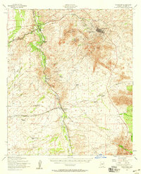
Coronado National Forest defines the northeastern corner of this desert landscape, where the terrain rises toward Smith Hill and Haberstock Hill. This 1970s survey illustrates a region shaped by ephemeral water sources and ranching infrastructure, with an extensive network of named washes such as Slavin Wash, Escalante Wash, and Clifford Wash draining the alluvial slopes. The reliance on managed water in this arid Cochise County environment is evident through numerous cattle tanks and wells, including Murphy Tank, Bennett Tank, and the Tenneco Well. Transportation in the area is limited to rugged tracks like the Jeep Trail and the more established Middlemarch Road, which cuts across the southern portion of the quadrangle. A prominent Pipeline also traverses the southwestern corner, indicating the modern utility corridors that began to cross these open range lands during the late twentieth century.
Find a feature on this map
27 named features on this map. Tap any name to fly to it.
Don’t see what you’re looking for? This feature index may not catch every label — zoom into the map to look around manually.
Map Details
Editions of this 1973 Haberstock Hill Map
2 editions found
Other maps of this area

1915 · Benson
USGS Topo · 1:125,000

1916 · Pearce
USGS Topo · 1:125,000

1922 · St. David
USGS Topo · 1:62,500

1925 · Gleeson
USGS Topo · 1:62,500

1926 · Courtland
USGS Topo · 1:62,500

1932 · Fairbank
USGS Topo · 1:62,500

1943 · Benson
USGS Topo · 1:125,000
1952 · Fairbank
USGS Topo · 1:24,000
1952 · Tombstone
USGS Topo · 1:24,000
1952 · Tombstone
USGS Topo · 1:62,500