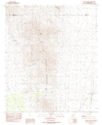
1982 Map of Hachita Peak
USGS Topo · Published 1982About this map
Little Hatchet Mountains dominate this high-desert landscape in southwestern New Mexico, as shown in this 1982 provisional survey. The terrain is marked by significant topographical landmarks including Hachita Peak and the nearby Howells Ridge, which together define the area's physical character. Movement through these elevations was historically channeled through natural corridors like Broken Jug Pass and Granite Pass, which offered passage between the peaks and the broad expanse of the Hachita Valley to the east.
Find a feature on this map
13 named features on this map. Tap any name to fly to it.
Don’t see what you’re looking for? This feature index may not catch every label — zoom into the map to look around manually.
Map Details
Editions of this 1982 Hachita Peak Map
This is the sole edition of this map. No revisions or reprints were ever made.
Other maps of this area

1918 · Big Hatchet Peak
USGS Topo · 1:62,500

1918 · Hachita
USGS Topo · 1:62,500

1918 · Walnut Wells
USGS Topo · 1:62,500

1918 · Playas
USGS Topo · 1:62,500

1919 · Playas
USGS Topo · 1:62,500

1923 · Walnut Wells
USGS Topo · 1:62,500

1955 · Douglas
USGS Topo · 1:250,000

1959 · Douglas
USGS Topo · 1:250,000

1961 · Douglas
USGS Topo · 1:250,000

1964 · Douglas
USGS Topo · 1:250,000