
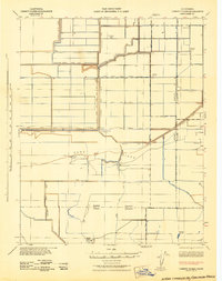
1942 Map of Hacienda Ranch
USGS Topo · Published 1957About this map
The Hacienda Ranch and its surrounding agricultural holdings dominate this landscape in the southern San Joaquin Valley, where early 1940s irrigation infrastructure defines every mile. This territory, once the bed of Tulare Lake, appears here as a highly organized network of reclamation districts and industrial-scale farms. Extensive water management systems including the Homeland Canal, Goose Lake Canal, and the Hacienda Spillway illustrate the transformation of this basin into a productive agricultural region.
Find a feature on this map
34 named features on this map. Tap any name to fly to it.
Don’t see what you’re looking for? This feature index may not catch every label — zoom into the map to look around manually.
Map Details
Editions of this 1942 Hacienda Ranch Map
2 editions found
Historical Maps of Burhans Ranch Through Time
144 maps found

1926 Burris Park
Kings County, CA

1926 Lethent
Kings County, CA

1927 Remnoy
Kings County, CA

1929 Guernsey
Kings County, CA

1929 Hacienda Ranch
Kings County, CA

1929 West Alpaugh
Kings County, CA

1929 Westhaven
Kings County, CA

1930 Avenal Gap
Kings County, CA

1930 Kettleman Plain
Kings County, CA

1930 La Cima
Kings County, CA

1930 Middle Dome
Kings County, CA

1931 Harvester
Kings County, CA

1932 Dudley Ridge
Kings County, CA

1932 El Rico Ranch
Kings County, CA

1932 Lone Tree Well
Kings County, CA

1932 West Camp
Kings County, CA

1933 Avenal Gap
Kings County, CA

1933 Chatom Ranch
Kings County, CA

1933 Kettleman Plain
Kings County, CA

1934 La Cima
Kings County, CA

1934 Los Viejos Hills
Kings County, CA

1934 Reef Ridge
Kings County, CA

1935 Chatom Ranch
Kings County, CA

1935 Harvester
Kings County, CA

1935 West Camp
Kings County, CA

1936 Dudley Ridge
Kings County, CA

1936 El Rico Ranch
Kings County, CA

1936 Lone Tree Well
Kings County, CA

1937 Reef Ridge
Kings County, CA
1942 Hacienda Ranch
Kings County, CA

1942 Tent Hills
Kings County, CA

1943 La Rambla
Kings County, CA

1943 Pyramid Hills
Kings County, CA

1943 Tent Hills
Kings County, CA

1950 Avenal Gap
Kings County, CA

1950 Burris Park
Kings County, CA

1950 Chatom Ranch
Kings County, CA

1950 Kettleman Plain
Kings County, CA

1950 Lethent
Kings County, CA

1950 Reef Ridge
Kings County, CA

1953 Garza Peak
Kings County, CA

1953 Kettleman Plain
Kings County, CA

1953 Pyramid Hills
Kings County, CA

1954 Avenal Gap
Kings County, CA

1954 Burris Park
Kings County, CA

1954 Dudley Ridge
Kings County, CA

1954 El Rico Ranch
Kings County, CA

1954 Guernsey
Kings County, CA

1954 Hacienda Ranch
Kings County, CA

1954 Hacienda Ranch NE
Kings County, CA

1954 Hacienda Ranch NW
Kings County, CA

1954 La Cima
Kings County, CA

1954 Lone Tree Well
Kings County, CA

1954 Los Viejos
Kings County, CA

1954 Remnoy
Kings County, CA

1954 Stratford SE
Kings County, CA

1954 West Camp
Kings County, CA

1956 Vanguard
Kings County, CA

1956 Westhaven
Kings County, CA

1963 La Cima
Kings County, CA

1994 Garza Peak
Kings County, CA

1994 Kettleman Plain
Kings County, CA

1994 Pyramid Hills
Kings County, CA

1994 Tent Hills
Kings County, CA

2012 Avenal Gap
Kings County, CA

2012 Burris Park
Kings County, CA

2012 Dudley Ridge
Kings County, CA

2012 El Rico Ranch
Kings County, CA

2012 Garza Peak
Kings County, CA

2012 Guernsey
Kings County, CA

2012 Hacienda Ranch
Kings County, CA

2012 Hacienda Ranch NE
Kings County, CA

2012 Hacienda Ranch NW
Kings County, CA

2012 Kettleman Plain
Kings County, CA

2012 La Cima
Kings County, CA

2012 Lone Tree Well
Kings County, CA

2012 Los Viejos
Kings County, CA

2012 Pyramid Hills
Kings County, CA

2012 Remnoy
Kings County, CA

2012 Stratford SE
Kings County, CA

2012 Tent Hills
Kings County, CA

2012 Vanguard
Kings County, CA

2012 West Camp
Kings County, CA

2012 Westhaven
Kings County, CA

2015 Avenal Gap
Kings County, CA

2015 Burris Park
Kings County, CA

2015 Dudley Ridge
Kings County, CA

2015 El Rico Ranch
Kings County, CA

2015 Garza Peak
Kings County, CA

2015 Guernsey
Kings County, CA

2015 Hacienda Ranch
Kings County, CA

2015 Hacienda Ranch NE
Kings County, CA

2015 Hacienda Ranch NW
Kings County, CA

2015 Kettleman Plain
Kings County, CA

2015 La Cima
Kings County, CA

2015 Lone Tree Well
Kings County, CA

2015 Los Viejos
Kings County, CA

2015 Pyramid Hills
Kings County, CA

2015 Remnoy
Kings County, CA

2015 Stratford SE
Kings County, CA

2015 Tent Hills
Kings County, CA

2015 Vanguard
Kings County, CA

2015 West Camp
Kings County, CA

2015 Westhaven
Kings County, CA

2018 Avenal Gap
Kings County, CA

2018 Burris Park
Kings County, CA

2018 Dudley Ridge
Kings County, CA

2018 El Rico Ranch
Kings County, CA

2018 Garza Peak
Kings County, CA

2018 Guernsey
Kings County, CA

2018 Hacienda Ranch
Kings County, CA

2018 Hacienda Ranch NE
Kings County, CA

2018 Hacienda Ranch NW
Kings County, CA

2018 Kettleman Plain
Kings County, CA

2018 La Cima
Kings County, CA

2018 Lone Tree Well
Kings County, CA

2018 Los Viejos
Kings County, CA

2018 Pyramid Hills
Kings County, CA

2018 Remnoy
Kings County, CA

2018 Stratford SE
Kings County, CA

2018 Tent Hills
Kings County, CA

2018 Vanguard
Kings County, CA

2018 West Camp
Kings County, CA

2018 Westhaven
Kings County, CA

2021 Avenal Gap
Kings County, CA

2021 Burris Park
Kings County, CA

2021 Dudley Ridge
Kings County, CA

2021 El Rico Ranch
Kings County, CA

2021 Garza Peak
Kings County, CA

2021 Guernsey
Kings County, CA

2021 Hacienda Ranch
Kings County, CA

2021 Hacienda Ranch NE
Kings County, CA

2021 Hacienda Ranch NW
Kings County, CA

2021 Kettleman Plain
Kings County, CA

2021 La Cima
Kings County, CA

2021 Lone Tree Well
Kings County, CA

2021 Los Viejos
Kings County, CA

2021 Pyramid Hills
Kings County, CA

2021 Remnoy
Kings County, CA

2021 Stratford SE
Kings County, CA

2021 Tent Hills
Kings County, CA

2021 Vanguard
Kings County, CA

2021 West Camp
Kings County, CA

2021 Westhaven
Kings County, CA