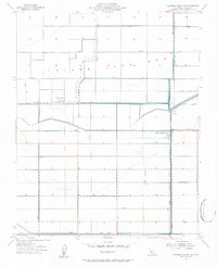
1954 Map of Hacienda Ranch NW
USGS Topo · Published 1956About this map
The Tulare Lake Bed dominates this mid-century landscape in Kings County, revealing a massive reclamation effort through an intricate grid of infrastructure. By the early 1950s, the terrain was meticulously organized by a network of engineered waterways, including the Homeland Canal, East Canal, and the Liberty Farms South Canal. These water systems supported agricultural operations like South Lake Farms and the El Rico Ranch, while the dry lake topography is still evidenced by the presence of Pelican Island.
Find a feature on this map
29 named features on this map. Tap any name to fly to it.
Don’t see what you’re looking for? This feature index may not catch every label — zoom into the map to look around manually.
Map Details
Editions of this 1954 Hacienda Ranch NW Map
3 editions found
Other maps of this area

1914 · Lost Hills
USGS Topo · 1:125,000

1928 · Corcoran
USGS Topo · 1:31,680

1929 · Hacienda Ranch
USGS Topo · 1:31,680

1929 · West Alpaugh
USGS Topo · 1:31,680

1931 · Harvester
USGS Topo · 1:31,680

1932 · El Rico Ranch
USGS Topo · 1:31,680

1932 · Dudley Ridge
USGS Topo · 1:31,680

1932 · West Camp
USGS Topo · 1:31,680

1932 · Lone Tree Well
USGS Topo · 1:31,680

1933 · Chatom Ranch
USGS Topo · 1:31,680