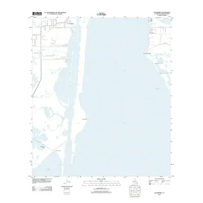
2012 Map of Hackberry
USGS Topo · Published 2012About this map
The low-lying coastal landscape of Hackberry and its surrounding wetlands are defined by a complex network of man-made and natural waterways. This 2012 survey depicts a region deeply tied to the shore of Calcasieu Lake, where the residential streets of the town give way to marshland and industrial access routes. The map records several named ridges and points that offer stable ground amidst the water, such as Billy Goat Ridge and Jubert Point. To the south, West Cove Camp sits near the intersection of West Cove Canal and the open lake, illustrating the maritime and recreational character of the parish. Significant hydrological modifications are visible through features like Number One Canal and Number Two Canal, which segment the terrain alongside natural drainage features like Long Point Bayou. Local history researchers will find a dense concentration of named family and access roads, including Devall Rd and Ben Wright Rd, documenting the contemporary footprint of this coastal community.
Find a feature on this map
43 named features on this map. Tap any name to fly to it.
Don’t see what you’re looking for? This feature index may not catch every label — zoom into the map to look around manually.
Map Details
Editions of this 2012 Hackberry Map
This is the sole edition of this map. No revisions or reprints were ever made.
Other maps of this area

1932 · Moss Lake
USGS Topo · 1:31,680

1932 · Lake Charles SW
USGS Topo · 1:31,680

1934 · Cameron
USGS Topo · 1:24,000

1934 · Holly Beach
USGS Topo · 1:24,000

1934 · Sweet Lake
USGS Topo · 1:24,000

1934 · Browns Lake
USGS Topo · 1:24,000

1934 · Grand Bayou
USGS Topo · 1:24,000

1935 · Cameron
USGS Topo · 1:31,680

1935 · Sweet Lake
USGS Topo · 1:31,680

1935 · Hackberry
USGS Topo · 1:31,680