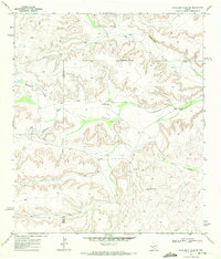
1969 Map of Hackberry Draw SE
USGS Topo · Published 1972About this map
Independence Creek and the North Fork Independence Creek carve through the high plateaus of West Texas in this 1969 survey of Terrell and Pecos Counties. The landscape is defined by the sharp relief of Hackberry Draw and a complex system of canyon drainages. Human activity in this arid region is largely centered on isolated cattle operations and resource extraction. The Porter Ranch and the Abilene Christian College Ranch represent the ranching heritage of the area, while the presence of a Pipeline, Drill Hole, and scattered Water Tanks point to the industrial efforts to manage water and energy across the desert terrain. An Indefinite Boundary separates the two counties, winding through the ridges and draws north of the primary creek beds.
Find a feature on this map
11 named features on this map. Tap any name to fly to it.
Don’t see what you’re looking for? This feature index may not catch every label — zoom into the map to look around manually.
Map Details
Editions of this 1969 Hackberry Draw SE Map
This is the sole edition of this map. No revisions or reprints were ever made.
Other maps of this area

1928 · Sanderson
USGS Topo · 1:125,000

1929 · Independence Draw Quadrangle
USGS Topo · 1:125,000

1954 · Fort Stockton
USGS Topo · 1:250,000

1958 · Fort Stockton
USGS Topo · 1:250,000

1969 · Circle Dot Ranch
USGS Topo · 1:24,000

1969 · Big Canyon Ranch NW
USGS Topo · 1:24,000
1969 · Seventeen Ranch
USGS Topo · 1:24,000

1969 · Hackberry Draw NW
USGS Topo · 1:24,000

1969 · Hackberry Draw NE
USGS Topo · 1:24,000
1969 · Hat-A Ranch
USGS Topo · 1:24,000