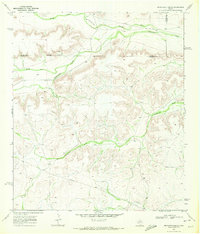
1969 Map of Seventeen Ranch
USGS Topo · Published 1972About this map
Independence Creek winds through the high plateau of the Trans-Pecos in this 1969 survey, defining a landscape dominated by isolated ranching outposts and deep drainage draws. The map illustrates the sprawling nature of West Texas landholdings, identifying the Seventeen Ranch, Coates Ranch, and Mitchell Ranch as the primary hubs of activity. These operations relied on a network of water features and improvements, such as Well 2807 and a remote Landing Strip, to maintain cattle and transport in the arid environment. The terrain is marked by significant topographical relief, where the North Fork Independence Creek and Seventeen Draw have carved intricate patterns into the limestone country. A prominent Pipeline and the Pecos Co Terrell Co boundary line provide the only other major human-made interruptions in an otherwise expansive ranching territory.
Find a feature on this map
15 named features on this map. Tap any name to fly to it.
Don’t see what you’re looking for? This feature index may not catch every label — zoom into the map to look around manually.
Map Details
Editions of this 1969 Seventeen Ranch Map
This is the sole edition of this map. No revisions or reprints were ever made.
Other maps of this area

1928 · Sanderson
USGS Topo · 1:125,000

1929 · Independence Draw Quadrangle
USGS Topo · 1:125,000

1954 · Fort Stockton
USGS Topo · 1:250,000

1958 · Fort Stockton
USGS Topo · 1:250,000

1969 · Circle Dot Ranch
USGS Topo · 1:24,000
1969 · Smoky Mountain Ranch
USGS Topo · 1:24,000

1969 · Circle Dot Ranch NE
USGS Topo · 1:24,000
1969 · Mitchell Draw
USGS Topo · 1:24,000

1969 · Hackberry Draw NE
USGS Topo · 1:24,000
1969 · Hackberry Draw SE
USGS Topo · 1:24,000